


Maps not only represent the world, they shape the way we see it. The revolutionary Peters Projection map presents countries in their true proportion to one another: it has been adopted by the UN, aid agencies, schools and businesses around the world.
WHAT IS THE PETERS MAP
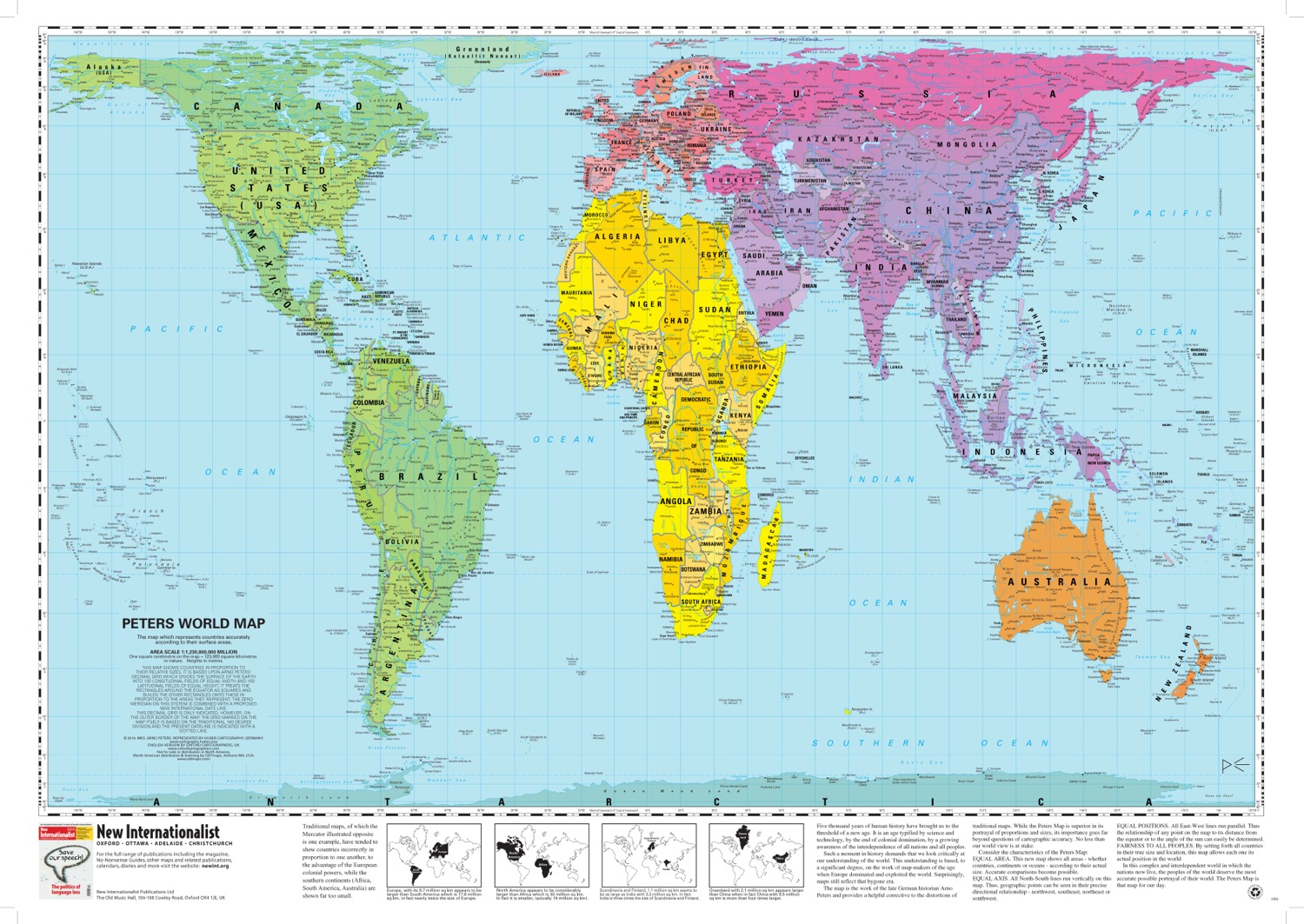
The Peters World Map is an Equal Area cylindrical projection with standard parallels at 45 degrees thus resulting in a distortion of shape which is stretched about the equator and squashed towards the poles, but having the great advantage that all countries are correct in size in relation to each other. Widely used in educational and business circles as an icon of the modern concept of world equality.
THE CHARACTERISTICS OF THE PETERS MAP
EQUAL AREA. The map shows all areas – whether countries, continents or oceans – according to their actual size. Accurate comparisons become possible.
EQUAL AXIS. All North-South lines run vertically on this map. Thus, geographic points can be seen in their correct geographical relationship – northwest, northeast, southwest or southeast.
EQUAL POSITIONS. All East-West lines run parallel. Thus the relationship of any point on the map to its distance from the Equator or to the angle of the sun can easily be determined.
FAIRNESS TO ALL PEOPLES. By setting forth all countries in their true size and location, this map allows each one its actual position in the world. In this complex and interdependent world, all peoples deserve the most accurate possible portrayal of their place in the world. The Peters Projection Map is that map for our time.
THE HISTORY
Five thousand years of human history have brought us to the threshold of a new age. It is an age typified by science and technology, by the end of colonial domination, and by a growing awareness of the interdependence of all nations and all peoples. Such a moment in history demands that we look critically at our view of the world as portrayed by the World Map. Surprisingly, to a significant degree this view is based on the work of cartographers from an age when Europe dominated and exploited the world.
Traditional map projections, of which the Mercator is one example, have tended to show countries incorrectly in proportion to one another, exaggerating the size of high latitude countries such as Canada and making tropical regions such as Africa appear much too small. Mercator’s projection was designed in the 16th century for navigational use but was adopted, inappropriately, for use as a world reference map. Most alternative projections now in use, such as Robinson, Van der Grinten, or Eckert IV, still do not preserve the quality of ‘equal area’. The Peters map, the work of the German historian Arno Peters, provides a helpful corrective to the distortions of traditional maps. While the Peters projection map is superior in its portrayal of proportions and sizes, its importance goes far beyond questions of cartographic accuracy – it challenges our view of the world.
Source: Oxford Cartographers