


Population : 1 591 232 habitants (est. 2002)
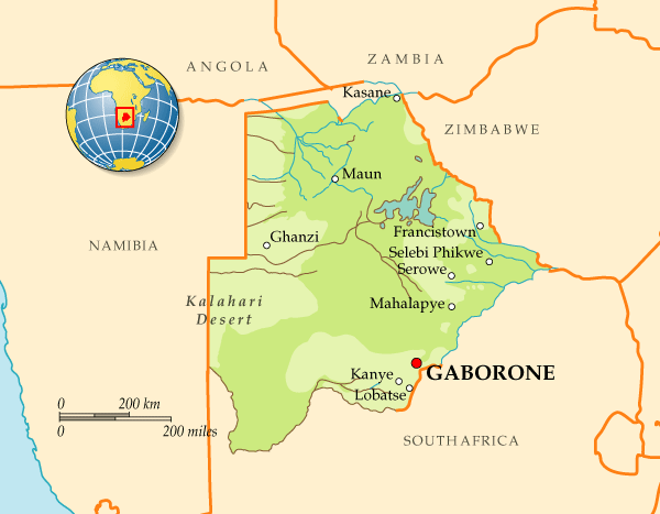
Pays voisins : Afrique du Sud, Namibie, Zambie, Zimbabwe
Densité : 2.65 hab./km²
Superficie : 600 372 km²
Capitale : Gaborone
Principales villes : Francistown, Lobatsi, Serowe, Selebi-Pikwe, Tutume, Bobonong
Point culminant : Tsodilo Hill 1 489 m.
Langue(s) parlée(s) : Tswana, Shona, Khoisan
Langue(s) officielle(s) : Anglais
Monnaie : Pula
Fête nationale : 30 septembre
Statut : République parlementaire

 1
1 The Book Of Princeville™ (Poetry) © http://thebookofprinceville.blogspot.com/2The Botswana Tribune http://botswanatribune.blogspot.com/3ANTI TOBACCO NETWORK BOTSWANA http://antitobacconetwork.blogspot.com/4LIKE the RETWEET http://cyberanalyst.blogspot.com/5Prinzeville Katlholo http://kalahariscribes.blogspot.com/


Botswana is flat, and up to 70% is covered by the Kalahari Desert. It is bordered by South Africa to the south and southeast, Namibia to the west and north, and Zimbabwe to the northeast. Its border with Zambia to the north near Kazungula, Zambia is poorly defined but at most is a few hundred meters long.
A mid-sized country of just over two million people, Botswana is one of the most sparsely populated countries in the world. Botswana was one of the poorest countries in Africa when it gained independence from the United Kingdom in 1966, with a GDP per capita of about US$70. Botswana has since transformed itself, becoming one of the fastest-growing economies in the world to a GDP (purchasing power parity) per capita of about $14,000. The country also has a strong tradition as a representative democracy.