That low pressure will bring cool, unsettled and very windy weather to that region. In fact, waves on the open waters of Lake Superior could reach as high as 20-25 feet.
A second area of low pressure will move into the Pacific Northwest and bring fall weather to the inter-mountain region as well as some below normal temperatures.
In the middle, we will find a small ridge of high pressure.
There is a special type of weather pattern created when you have low, high, low as you look from west to east. It is visually represented below in a picture from the GFS forecast model that was ran on Sunday night at 6 pm.
The picture is a forecast of what the jet stream is predicted to look like at 500 millibars, or approximately 20,000 feet, on Tuesday night at 6 pm.
Look at the pattern of low pressure, high pressure, low pressure -- going from west to east...does it look like anything you might know...think Greek letters.

This type of pattern in the upper atmosphere is called an Omega Block because it looks like the greek letter Omega.
It is important for a meteorologist to notice this type of pattern in the upper atmosphere because it can create weather patterns that persist for several days.
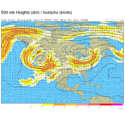
Below is a picture from the same model run where I took the snapshot above...but this picture is for 180 hours out into the future -- which would be Sunday night at 6 pm. We are still looking at 500 mb, which is the jet stream level at approximately 20,000 feet.

It still shows an Omega Block -- only the ridge in the middle has flattened out just a bit. This could be a sign that the flow above wants to open up and the low pressures that have been sitting in place may move out.
So what does this mean exactly?
In the short term, areas under the troughs, or low pressure, will be cool and unsettled. The area under the high pressure, which is the ridge in the middle of the first picture, will be mostly on the quiet and mild side.
And if you are on the edges of the low pressure, it will be windy due to the pressure difference, or gradient, between the low pressures over the east and west and the high pressure in the middle.
So if this forecast verifies, it will be turning cooler, unsettled and windy for places like Salt Lake City, Denver, Chicago, Minneapolis, Detroit and New York this week.
While it should be fairly quiet and seasonal in places like Wichita, Kansas City, Dallas, Oklahoma City and Little Rock this week -- with the exception of Thursday when we will see the chance for a severe weather outbreak in the middle of the nation as the low pressure intensifies over the Rockies.
Stay tuned to the forecast over the next several days to see how this Omega block pattern plays out. Sometimes it resolves quickly and sometimes it can keep the flow in the upper atmosphere stagnant for several days.


